 |
| Eerien, Equirectangular and Lambert Conformal Conic Projections |
Points of interest include a warped view of Feorad Island (compare it with the Lambert Conformal Conic views in the Feorad article to see what a huge difference the projection makes); the positioning of the Great Caldera in regard to the surrounding terrain; the northern part of Omfall, another huge continent which stretches down to the Antarctic Circle; the Aesean Duct, a narrow sea passage bisecting the two great continents; and of course Eerien herself.
Eerien is home to Calidar's tallest mountains, its highest peak reaching a towering 8,925 m (29,281 feet). As such, the mountain design is of great importance.
The bottom image shows the true shape of Eerien, projected onto a shape-preserving Lambert Conformal Conic Projection.
The next images show the progression of Eerien's pre-erosion height map design. This is currently the most developed area outside of the Great Caldera, although other parts of the world are slowly catching up.
 |
| Eerien, Lambert Conformal Conic Projection |
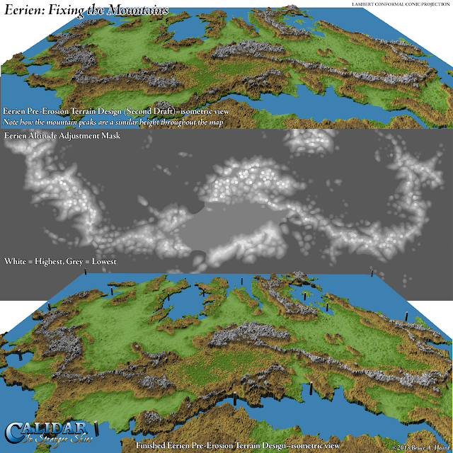
The top image is a preview of the design, straight from Photoshop. If you look closely, you should be able to make out that the mountains are all roughly the same height throughout the map - legions of white peaks everywhere. Eerien is supposed to be extremely mountainous, but we wanted to introduce some variation to the heights. Considering the sheer size of the base map – a staggering 22,737 × 14,049 pixels – it's not that easy a thing to fix.
However, I came up with an idea, which you can see in the middle image. It's an adjustment mask which I applied to the base map. There is a single pure white spot, which remains at full height. All the rest are increasingly darker shades of grey, which pushed down the height of the mountain peaks under them. This was all painted manually, and finally blurred before being applied to the height map.
The bottom image shows the result. At first glance you may be wondering what the big deal is, but look closely and you should be able to see quite a lot of variation has been introduced into the mountain ranges.
One last point: did you notice all the pillars scattered across the bottom image? These are there for a specific purpose, and of course are only there as temporary markers. Would you like to hazard a guess as to what they are marking? Hint: there are lots of them due to the sheer size of the map.
The answer is that they are scale markers, to help keep all the altitudes in sync. There are lots of them because the map is split up into smaller parts for erosion, and each part must have a marker on it. The height of the markers is 8,925 m, and on the height map they are pure white, marking the top of the world.
Without these markers, the programs which handle the height maps would make the highest height on each map white, and scale the rest accordingly. That would mean mountains of 8,925 m all over the world!
he next image shows two renditions of the same height map. I'm sure you'll agree that the colour version is much easier to read, but unfortunately when I need to make manual changes to the map, I generally have to work on the black and white version. It's tricky, to say the least.
 |
| Eerien Eroded Height Map, Lambert Conformal Conic Projection |
Eerien's erosion has resulted in some very interesting terrain. My favourite part is the plateau, which has gained a Grand Canyon-like ravine. Immediately north of the plateau are the highest mountains in the world, so it's a fascinating area all round.
 |
| 3D Views of Eerien, Lambert Conformal Conic Projection |
At the top you can see the continent in its entirety.

 The middle row shows two different perspectives on Calidar's version of the Himalaya Mountains and the Tibetan Plateau. These are the highest mountains in the world, although it may be difficult to see that at these distances.
The plateau itself is not entirely flat, with its most predominant feature being the massive ravine which snakes its way through. Presumably all the runoff from the mountains to the north has carved this huge scar into the plateau over many aeons.

 Finally there is a closer look at the lowlands to the north of the great mountains, and then a look at the imposing mountains themselves from nearby.
That's it for Eerien for now. As the Kickstarter start date approaches, we will continue to reveal the World of Calidar.

No comments:
Post a Comment